Atlantic Storm Brings Heavy Rains, Flooding to Carolina Coast \ Newslooks \ Washington DC \ Mary Sidiqi \ Evening Edition \ An unnamed Atlantic storm hit the southeastern U.S. coast on Monday, bringing heavy rain, strong winds, and significant flooding to parts of North and South Carolina. The system, classified as Potential Tropical Cyclone No. 8, failed to develop into a named storm but caused widespread disruption, closing schools and prompting temporary tropical storm warnings. While it didn’t reach the status of Tropical Storm Helene, it dumped over a foot of rain in some areas, flooded roads, and knocked out power as emergency crews worked to mitigate damage.
“Unnamed Storm Causes Flooding Across Carolinas” Quick Look
- Storm impact: Heavy rain and winds from an unnamed storm hit the southeastern U.S. coast, flooding parts of North and South Carolina.
- Flooding: Up to 18 inches of rain fell in some areas, with winds gusting up to 65 mph.
- Warnings issued: Tropical storm warnings were briefly in place for both states before being lifted Monday afternoon.
- School closures: Coastal Carolina University and other schools shut down due to dangerous weather conditions.
- Outlook: The storm is expected to dissipate by Wednesday, with flash flooding still a concern across several states.
Atlantic Storm Deep Look
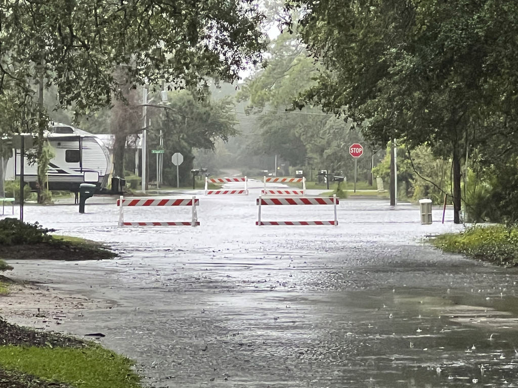
On Monday, an unnamed storm system hit the southeastern U.S. coast, bringing torrential rain, strong winds, and severe flooding to the Carolinas. The storm, officially classified as Potential Tropical Cyclone No. 8, failed to organize into a named tropical storm, but nonetheless wreaked havoc across coastal regions. Flooded roads, strong gusts, and school closures underscored the storm’s impact as it swept through North and South Carolina, leaving thousands of residents affected.
Although the system didn’t develop enough to become the eighth named storm of the Atlantic hurricane season, which would have been named Helene, it caused significant damage. The storm remained powerful, even without full tropical cyclone status, dropping more than a foot of rain in some areas and flooding roads, neighborhoods, and businesses.
Heavy Flooding and Winds
The center of the storm was located near the South Carolina coast on Monday afternoon, according to the U.S. National Hurricane Center (NHC). While the system was never organized enough to earn a name, it still brought intense weather conditions. Radar estimates showed some areas, particularly south of Wilmington, North Carolina, received over 12 inches (30 centimeters) of rainfall. Nearby Wrightsville Beach reported a wind gust of 65 mph (105 kph), adding to the storm’s intensity.
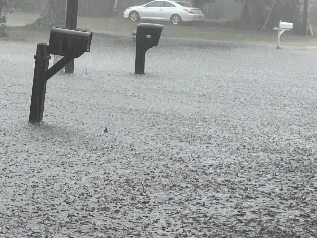
In Brunswick County, North Carolina, floodwaters reached waist height in areas near the courthouse, according to the local sheriff’s office. Further down the coast, in Carolina Beach, floodwaters inundated entire city blocks, with dozens of vehicles partially submerged as rainwater climbed up to their doors. Officials there warned residents to stay inside as radar showed that up to 18 inches (46 centimeters) of rain had fallen in certain areas. “There are areas where it’s unsafe to travel. We’re urging everyone to stay off the roads and avoid flooded areas,” a Carolina Beach official said.
In addition to flooding, the storm’s high winds battered coastal areas. Trees were downed, and some power lines were damaged, leaving homes and businesses without power. “The wind was howling, and we couldn’t believe how fast the water rose,” said one Carolina Beach resident. “We’ve had storms before, but this one flooded our street in no time.”
Tropical Storm Warning and School Closures
The storm system prompted a brief tropical storm warning for parts of the North Carolina and South Carolina coasts. The warning was issued late Sunday as meteorologists initially predicted the system could strengthen into a tropical or subtropical storm. However, by Monday afternoon, the system’s winds and rainfall had become less organized, leading the NHC to cancel the warning. At its peak, the storm’s maximum sustained winds reached 35 mph (55 kph), falling just below the threshold needed to qualify as a tropical storm. Forecasters noted that most of the strongest winds were concentrated in outer rain bands rather than near the storm’s center.
“We were closely monitoring this system over the weekend. It had a chance to become a named storm, but by Monday, it lost some of its structure,” said Carl Morgan, a meteorologist with the National Weather Service (NWS) in Wilmington. “There are still strong winds out there, they’re just not concentrated near the center as we typically see with tropical storms.”
Despite the lack of formal tropical storm status, the storm caused widespread disruptions. Coastal Carolina University canceled classes for the day, and several schools and businesses in flood-prone areas also closed in response to the extreme weather. Local authorities warned residents to stay inside, avoid flooded roads, and heed any evacuation orders. “Flooding in these areas can be unpredictable and dangerous. We are urging everyone to exercise caution,” said a South Carolina emergency official.
Significant Rainfall and Ongoing Flood Risk
Forecasters predicted that the storm would drop between 4 to 8 inches (10 to 20 centimeters) of rain across northeastern South Carolina and southeastern North Carolina through Tuesday, with isolated areas receiving up to 10 inches (25 centimeters). The NHC also warned that more rain was expected over the following days, especially across parts of North Carolina and Virginia, where an additional 1 to 3 inches (2.5 to 8 centimeters) could fall by Wednesday. The rainfall was expected to trigger flash flooding in urban areas, minor river flooding, and potential landslides in more vulnerable regions.
“The rainfall totals are significant, and flooding will remain a concern over the next 24 to 48 hours,” said Morgan from the NWS. He added that the greatest risk would be in low-lying areas and locations with poor drainage systems, where water could accumulate quickly.
In the meantime, the storm was forecast to weaken and dissipate as it moved further inland, likely losing strength over the Carolinas by late Wednesday. However, the damage already done was clear, with dozens of communities facing flooded homes, washed-out roads, and ongoing recovery efforts.
Active Hurricane Season Still Expected
The unnamed storm marked yet another event in what experts predict to be a highly active Atlantic hurricane season. According to the National Oceanic and Atmospheric Administration (NOAA), near-record sea surface temperatures and the possible influence of La Niña are contributing to heightened storm activity in the Atlantic basin. Emergency management officials have repeatedly stressed the importance of preparation, as more storms are expected in the months ahead.
Last month, NOAA updated its hurricane outlook, continuing to predict an above-average season for the Atlantic, with several more named storms expected to form before the season ends in late November. “We’ve already seen quite a few storms, and the conditions are there for more to develop,” said a NOAA spokesperson. “People in hurricane-prone areas should be ready.”
While Potential Tropical Cyclone No. 8 never reached named storm status, its impact serves as a reminder of the unpredictability of these systems and the damage they can cause even without a formal classification.
Storm Gordon Weakens, But Remains Under Watch
Meanwhile, elsewhere in the Atlantic, Tropical Storm Gordon weakened into a tropical depression as it moved through open ocean waters. Forecasters are continuing to monitor Gordon, with the possibility that the storm could either dissipate entirely or strengthen back into a tropical storm. “We’re watching Gordon closely, as it could still reorganize in the coming days,” said Morgan.