Heavy Snowfall to Hit Mid-Atlantic: Winter Storm Warning Issued \ Newslooks \ Washington DC \ Mary Sidiqi \ Evening Edition \ A Winter Storm Warning has been issued for the Mid-Atlantic region, with 4 to 8 inches of snow expected from Tuesday afternoon through early Wednesday. Hazardous travel conditions are likely, as snowfall rates could reach 1 to 2 inches per hour during the storm’s peak. Authorities are urging residents to prepare for delays, difficult road conditions, and possible flight cancellations. Another storm system may develop later in the week.
Mid-Atlantic Winter Storm: Quick Looks
- Storm Timing: Snow starts Tuesday late morning, intensifying in the afternoon and evening.
- Heavy Snowfall: 4 to 8 inches expected, with rates of 1 to 2 inches per hour at peak.
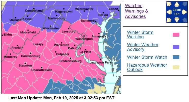
- Winter Storm Warning Issued: Covers D.C., central/southern Maryland, and parts of Virginia.
- Travel Impacts: Treacherous evening commute, reduced visibility, and possible airport delays.
- Road Preparations: Crews are pre-treating roads, with plows ready as snow accumulates.
- Air Travel Disruptions: Major airports Reagan, Dulles, and BWI monitoring storm impacts.
- More Snow Possible: Meteorologists are tracking additional winter systems later this week.
Deep Look
A significant winter storm is set to impact the Mid-Atlantic region, bringing heavy snow, hazardous travel conditions, and potential disruptions. The National Weather Service (NWS) in Baltimore and Washington issued a Winter Storm Warning on Monday afternoon, alerting residents in Washington, D.C., central and southern Maryland, and parts of Virginia to prepare for treacherous conditions from Tuesday afternoon through early Wednesday.
According to forecasters, this storm will bring widespread snowfall accumulations between 4 to 8 inches, with some localized areas possibly seeing even higher totals. Snowfall rates could reach 1 to 2 inches per hour, particularly during the height of the storm on Tuesday afternoon and evening, significantly impacting roadways, air travel, and daily routines.
Timeline and Snowfall Breakdown
The storm will unfold in multiple phases:
- Tuesday Late Morning (Around 11 AM – 12 PM): Snow begins lightly across the region, with scattered flakes falling in D.C., Maryland, and Virginia. Initial accumulations will be minor.
- Tuesday Afternoon (1 PM – 5 PM): Snowfall becomes heavier and more widespread, with rates increasing to 1 to 2 inches per hour. This is when road conditions will begin to deteriorate quickly.
- Tuesday Evening Commute (5 PM – 9 PM): This period is expected to have the most significant travel impacts. Snowfall will be at its peak, and roads will become increasingly hazardous. Reduced visibility, snow-covered highways, and icy conditions could cause accidents and delays.
- Tuesday Night (9 PM – 2 AM): Snow continues steadily, though intensity will begin to weaken. Roads will remain slippery and treacherous as plows work to clear accumulation.
- Early Wednesday Morning (2 AM – 7 AM): Snow tapers off, possibly transitioning to a light wintry mix in some areas. Little to no additional accumulation is expected after this point.
While some lingering flurries may persist into Wednesday morning, the storm’s primary impacts will have already occurred. By mid-morning Wednesday, most precipitation should move out, allowing cleanup efforts to begin.
Travel Disruptions & Road Conditions
Officials are urging residents to take precautions, as this storm is expected to create dangerous driving conditions throughout the region. Rapidly accumulating snow will make roads slick, and strong winds may cause blowing and drifting snow, further reducing visibility.
- The Maryland State Highway Administration (SHA) has already begun pre-treating major roads and highways. Crews will work throughout the storm to plow snow, but rapid accumulation could outpace efforts, especially during peak snowfall hours.
- The Virginia Department of Transportation (VDOT) has also issued warnings about icy roads and deteriorating travel conditions, advising commuters to stay off the roads unless absolutely necessary.
- Local and state officials are advising drivers to allow extra time for travel, reduce speed, and carry emergency supplies in their vehicles.
The Tuesday evening commute will likely be the most dangerous period, as plows may struggle to keep up with the heavy snowfall rates. Commuters should consider leaving work early or working remotely if possible.
Flight Delays & Airport Closures Possible
This storm will not only impact roads but also air travel, with major airports in the region bracing for delays and cancellations.
- Ronald Reagan Washington National Airport (DCA), Dulles International Airport (IAD), and Baltimore-Washington International Airport (BWI) are all closely monitoring the storm’s progress.
- The Federal Aviation Administration (FAA) has warned of possible flight disruptions, especially on Tuesday afternoon and evening when snowfall rates are at their highest.
- Passengers should check with their airlines for the latest updates and prepare for potential flight delays or cancellations.
As seen in past winter storms, heavy snowfall can cause runways to shut down temporarily, leading to cascading delays not just locally but at connecting airports nationwide.
Emergency Preparedness & Safety Tips
With a high-impact winter event approaching, residents should take precautions to ensure safety:
- Prepare an emergency kit with food, water, blankets, flashlights, and extra batteries in case of power outages.
- Stock up on essential groceries and medications before the storm arrives.
- Charge all electronic devices ahead of time.
- If driving is unavoidable, keep an emergency kit in your car, including a shovel, extra warm clothing, and a flashlight.
- Check for school closures and business operation updates, as many schools and offices may shift to remote learning/work due to dangerous conditions.
More Winter Weather Ahead?
This storm is just one of several systems meteorologists are tracking in the active winter pattern affecting the Mid-Atlantic region. Another storm system could develop later in the week, bringing additional snow or a wintry mix to parts of the area.
- Forecasters will closely monitor the development of this second system, which could impact the region Friday into Saturday.
- Depending on the storm’s track, additional snow accumulation or freezing rain may create more travel disruptions over the weekend.
While this season has seen variable winter conditions, February is often known for strong nor’easters and impactful winter storms. Residents should stay weather-aware and continue to monitor updates from the National Weather Service (NWS) and local meteorologists.
Final Thoughts
The Mid-Atlantic winter storm is shaping up to be a major weather event, with heavy snowfall, treacherous travel conditions, and potential flight disruptions. Residents in Washington, D.C., Maryland, and Virginia should take necessary precautions ahead of the storm’s arrival and stay off the roads if possible during peak snowfall times.
As the storm approaches, stay updated with official forecasts, have an emergency plan, and prepare for a slow and hazardous commute Tuesday evening. With another winter system possible later in the week, this active pattern may continue to bring winter weather challenges to the region.