Hurricane Watches Issued for Cuba and Mexico as Helene Forms \ Newslooks \ Washington DC \ Mary Sidiqi \ Evening Edition \ Hurricane watches were issued for parts of Cuba and Mexico as a storm cluster near the Cayman Islands is expected to strengthen into Hurricane Helene. The storm is forecast to intensify into a major hurricane and may affect Florida’s Gulf Coast later this week. Florida has already declared a state of emergency in anticipation of potential impacts.
Hurricane Helene Approaches: Quick Looks
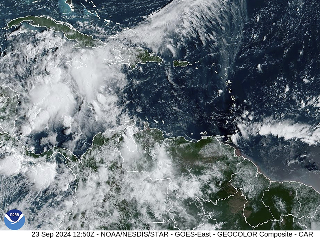
- A storm cluster near the Cayman Islands is expected to strengthen into Hurricane Helene.
- Helene is forecast to become a major hurricane (Category 3) as it moves toward the Gulf Coast.
- Florida Governor Ron DeSantis declared a state of emergency in 41 counties.
- Heavy rainfall and storm surge are expected for parts of Cuba, Mexico, and the U.S. Gulf Coast.
- Up to 8 inches of rain is forecast for Cuba and the Cayman Islands, with isolated totals of 12 inches.
- The National Hurricane Center warns of potential life-threatening conditions along the Florida Panhandle and west coast.
- Helene would be the eighth named storm of the 2023 Atlantic hurricane season.
Deep Look:
Hurricane watches were issued on Monday for parts of Cuba and Mexico as a developing storm system located south of the Cayman Islands is expected to intensify into a major hurricane in the coming days. The National Hurricane Center (NHC) forecasts the disturbance to become Hurricane Helene by Wednesday as it moves northward toward the U.S. Gulf Coast.
Brad Reinhart, a senior hurricane specialist with the NHC, confirmed that the system could reach major hurricane status, defined as a Category 3 storm with sustained winds of at least 111 mph (178 kph). “It could certainly become a major hurricane,” Reinhart said, though he emphasized that it’s still too early to determine precisely where the storm might make landfall. He urged residents in Florida’s Panhandle and the west coast to remain vigilant, as conditions could quickly worsen.
In preparation, Florida Governor Ron DeSantis declared a state of emergency in 41 counties on Monday, warning residents to be prepared for the possible impacts. Reinhart noted that while the storm could potentially strengthen into a Category 4 hurricane, that scenario is not yet the most likely outcome. “There’s always some potential, but we’ll have to wait and see,” he added.
As of Monday, the disturbance was situated about 105 miles (170 kilometers) southwest of Grand Cayman, with sustained winds of 35 mph (55 kph), moving north-northwest at 7 mph (11 kph). The storm is expected to become a tropical storm by Tuesday, bringing tropical storm conditions to parts of Florida by Wednesday and intensifying into a major hurricane by the time it reaches the northeast Gulf Coast on Thursday.
“We’re looking at a pretty aggressive forecast for intensification over the next few days,” Reinhart said, highlighting the importance of staying on high alert, especially given the rapid development of the storm.
The primary factors fueling the system’s strengthening include unusually warm sea surface temperatures, favorable atmospheric conditions, and light upper-level winds. The sea temperatures in the area, combined with a moist atmosphere that supports thunderstorm development, are key drivers in the storm’s rapid intensification.
A hurricane watch has been issued for Cuba’s Pinar del Rio province and parts of eastern Mexico, extending from Cabo Catoche to Tulum. Additionally, a tropical storm warning is in effect for eastern Mexico from Rio Lagartos to Tulum and the Cuban provinces of Artemisa, Pinar del Rio, and the Isle of Youth. Florida’s Dry Tortugas and the Lower Keys, south of Seven Mile Bridge, are also under a tropical storm watch.
While the exact path and intensity of the storm remain uncertain, the National Hurricane Center has warned of increasing risks of life-threatening storm surge and damaging hurricane-force winds for the Florida Panhandle and the state’s west coast. The center’s statement cautioned, “The potential for life-threatening storm surge and damaging hurricane-force winds along the coast of the Florida Panhandle and the Florida west coast is increasing.”
Forecasts indicate heavy rainfall in the coming days, particularly in western Cuba and the Cayman Islands, which could receive up to eight inches of rain, with isolated totals as high as 12 inches (30 centimeters). Eastern Mexico’s Yucatán Peninsula is expected to see up to 4 inches (10 centimeters) of rain, with isolated totals exceeding 6 inches (15 centimeters).
Additionally, up to 4 feet (1.2 meters) of storm surge is predicted in parts of Cuba and Mexico. Flooding is also a significant concern for the southeastern U.S., with projections calling for up to six inches (15 centimeters) of rain and isolated totals of up to 10 inches (25 centimeters) across the region, potentially triggering flash floods and river flooding beginning on Wednesday.
In anticipation of the storm’s approach, authorities in the Cayman Islands have already begun taking precautionary measures. Schools were closed on Monday as forecasters warned of heavy flooding and other hazards associated with the developing storm. The disturbance is expected to pass between Cuba and Mexico’s Yucatán Peninsula late Tuesday night, intensifying as it moves over the warm waters of the Gulf of Mexico.
If Helene forms as expected, it will become the eighth named storm of the 2023 Atlantic hurricane season, which runs from June 1 through November 30. The National Oceanic and Atmospheric Administration (NOAA) has forecast an above-average hurricane season due to record-warm ocean temperatures. NOAA predicts 17 to 25 named storms this year, with four to seven major hurricanes of Category 3 or higher.
As Helene’s path becomes clearer in the coming days, residents in the affected regions are urged to stay informed and prepared. The next few days will be critical as the storm strengthens and approaches the U.S. coast.