Massive U.S. Storm to Bring Blizzards, Tornadoes, and Flooding \ Newslooks \ Washington DC \ Mary Sidiqi \ Evening Edition \ A massive March storm will impact over 100 million people across the U.S. starting Friday, bringing a mix of blizzards, tornadoes, wildfires, and flooding. Scientists attribute the storm’s strength to extreme temperature contrasts and jet stream activity. The system could become a bomb cyclone, intensifying wind and rainfall as it moves eastward through the weekend.
Severe U.S. Storm Threatens Millions: Quick Looks
- 100 Million at Risk: A sprawling storm system will impact the Great Plains, Midwest, and East Coast.
- Extreme Weather Mix: Expect wildfires, blizzards, tornadoes, and flooding over several days.
- Severe Winds: Gusts up to 80 mph (130 kph) could cause fire hazards in Texas, New Mexico, and Oklahoma.
- Blizzard Conditions: Heavy snow and high winds expected in the Dakotas, Minnesota, and Rockies.
- Tornado Threat: Thunderstorms capable of producing tornadoes and hail will move from the Gulf Coast to the Midwest.
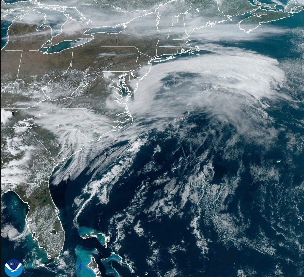
- East Coast Impact: By Sunday, expect strong winds and flash flooding along the I-95 corridor.
- Possible Bomb Cyclone: Meteorologists warn the storm could intensify rapidly, increasing its severity.
Deep Look
A powerful and expansive storm system is set to impact over 100 million Americans as it sweeps from the Great Plains to the East Coast starting Friday. The multi-day weather event will bring high winds, blizzard conditions, severe thunderstorms, and flash flooding, with potential impacts stretching from Canada to the Gulf of Mexico.
Meteorologists emphasize the storm’s strength and widespread effects, though its timing in early spring is not unusual. Extreme weather this time of year results from sharp contrasts between warming spring air and lingering winter cold, creating volatile atmospheric conditions.
“If there’s a time of the year where a storm like this can deliver these coast-to-coast impacts, we are in it,” said Benjamin Reppert, a meteorologist at Penn State University.
Friday: Fire Danger in the Southwest, Blizzard in the North
On Friday, the storm will bring dangerous winds across a vast stretch of the U.S., from the Canadian border to the Rio Grande.
- Wildfire Threat: Wind gusts up to 80 mph (130 kph) will create high fire danger in Texas, New Mexico, and Oklahoma.
- Blizzard Conditions: The storm will produce heavy snow and strong winds in parts of the Rockies, Dakotas, and Minnesota, potentially leading to whiteout conditions.
- Tornadoes and Severe Thunderstorms: The central U.S. faces an increasing risk of hail and tornadoes, especially from the Gulf Coast to Wisconsin.
Saturday: Tornadoes and Flooding Move East
As the storm tracks eastward on Saturday, it will bring more destructive weather to the South and Midwest:
- Severe Storms: States from Louisiana and Mississippi to Tennessee and Florida could see tornadoes, large hail, and damaging winds.
- Flooding Risk: Heavy rainfall threatens low-lying areas from the Gulf Coast through the Ohio Valley.
Sunday: East Coast Faces Flash Flooding and Strong Winds
By Sunday, the storm will slam into the East Coast, bringing strong winds, heavy rainfall, and potential flash flooding.
- Interstate 95 Corridor: The storm will drench major cities from Washington, D.C., to Jacksonville, Florida.
- Localized Flash Flooding: Saturated areas will face rising water levels, increasing the risk of road closures and travel disruptions.
Why Is This Storm So Intense?
Meteorologists point to several key factors that are supercharging the storm’s strength:
1. Extreme Temperature Contrasts
- The upper atmosphere over the central and eastern U.S. is near record warmth for this time of year.
- Behind the storm, the western U.S. is experiencing one of its coldest air masses on record.
- This sharp contrast fuels the storm’s intensity, creating conditions for powerful winds and extreme weather shifts.
2. Possible Bomb Cyclone Formation
- Russ Schumacher, a climatologist at Colorado State University, warns that the storm could rapidly intensify into a “bomb cyclone” by Friday night.
- A bomb cyclone occurs when a storm’s atmospheric pressure drops significantly within 24 hours, increasing wind speeds and rainfall intensity.
3. Influence of the Jet Stream
- The jet stream is positioned southward, creating ideal conditions for the storm to pull in moisture and energy.
- This leads to greater instability, fueling the storm’s widespread impacts.
4. Gulf of Mexico’s Warmer Waters
- The storm will tap into heat and moisture from the Gulf of Mexico, which is currently 2 to 4°F (1.1 to 2.2°C) above historical averages.
- The warmer waters increase atmospheric moisture, contributing to stronger storms, heavier rainfall, and more severe tornadoes.
“You kind of have this Goldilocks situation,” said Ryan Torn, professor of atmospheric sciences at the University at Albany, referring to the storm’s ideal mix of atmospheric ingredients.
How to Prepare for the Storm
Authorities urge residents in affected areas to take precautions:
- Monitor Weather Alerts: Stay updated with National Weather Service warnings.
- Prepare for Power Outages: High winds could knock out power in multiple states.
- Plan for Travel Disruptions: Flooding and snowstorms could create dangerous road conditions.
- Secure Outdoor Objects: Strong winds could cause debris and property damage.
Looking Ahead: What’s Next?
- The storm is expected to exit the U.S. by Monday, but cold air behind the system could bring another wave of snow and frost to parts of the Midwest and Northeast.
- Meteorologists will monitor the potential for additional storms as spring weather patterns continue to shift.
With 100 million people in its path, this March storm could be one of the most significant weather events of the season.
Massive U.S. Storm Massive U.S. Storm Massive U.S. Storm