Winter Storm to Bring Heavy Snow Across Northeast \ Newslooks \ Washington DC \ Mary Sidiqi \ Evening Edition \ A strong winter storm is set to bring moderate to heavy snowfall across the Upper Great Lakes on Saturday, before intensifying over the Northeast overnight. 4 to 8 inches of snow is expected in parts of Minnesota and the Great Lakes, while upstate New York and New England could see up to a foot by Sunday. The storm is moving quickly, but hazardous travel conditions due to low visibility, snow-covered roads, and freezing rain are expected, particularly in the Ohio Valley and Central Appalachians.
Northeast Snowstorm Quick Looks
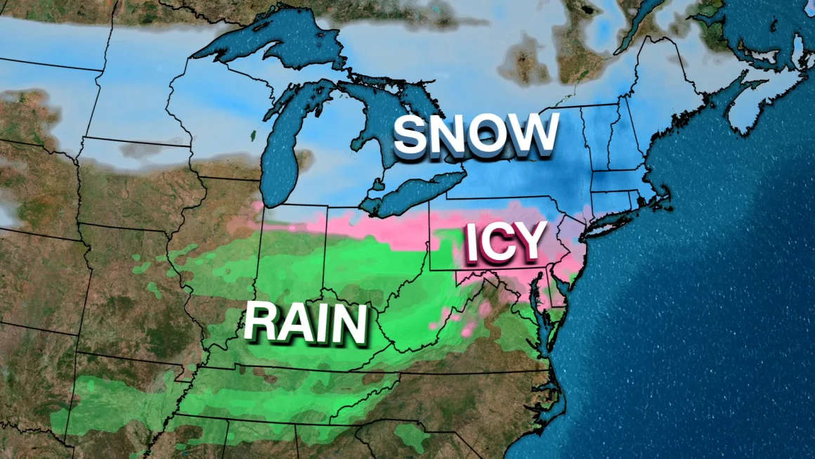
- A fast-moving winter storm will bring heavy snow across the Upper Great Lakes and Northeast.
- 4 to 8 inches of snow is forecast for Minnesota and parts of the Great Lakes on Saturday.
- Upstate New York and New England could receive up to a foot of snow by Sunday.
- Hazardous travel conditions are likely due to snow-covered roads and low visibility.
- A wintry mix of snow, sleet, and freezing rain could bring significant icing to the Central Appalachians.
- Power outages are possible due to freezing rain on roadways and ice accumulation.
- The storm is moving quickly, with calmer weather expected by Sunday afternoon.
Deep Look
A strong winter storm is sweeping across the Upper Great Lakes this weekend, bringing moderate to heavy snowfall before intensifying over the Northeast. The National Weather Service (NWS) has issued warnings as the system moves from the central and southern plains into the Great Lakes region on Saturday, before delivering significant snowfall and ice accumulation to parts of New York and New England overnight into Sunday.
As the storm moves northeast, travel conditions will deteriorate due to heavy snowfall, low visibility, and icy roads. Parts of Minnesota, Wisconsin, and Michigan are expected to receive 4 to 8 inches (10 to 20 cm) of snow, while upstate New York and New England could see up to a foot (30 cm) of snow accumulation by Sunday morning.
While the storm is moving quickly, its impact will be significant, with dangerous road conditions, potential power outages, and flight delays expected in affected regions.
Heavy Snowfall to Impact Great Lakes & Northeast
According to the NWS, the storm will first bring moderate to heavy snow across portions of Minnesota, Wisconsin, and the Upper Peninsula of Michigan throughout Saturday. Snowfall in these areas is expected to reach between 4 to 8 inches, making roads slick and hazardous for travel.
As the storm strengthens overnight, it will bring more intense snowfall to upstate New York and northern New England. The latest models indicate 10 to 12 inches of snow for cities such as Buffalo, Albany, and Burlington, with localized areas possibly receiving more than a foot of snow.
Major impacts include:
- Reduced visibility due to heavy snowfall.
- Snow-covered roads creating hazardous driving conditions.
- Flight delays and cancellations at major airports.
- Potential school and business closures on Monday due to lingering snow accumulation.
Icy Conditions Expected in the Ohio Valley & Central Appalachians
In addition to heavy snow, the system will bring a wintry mix of snow, sleet, and freezing rain to parts of the Ohio Valley, northern Mid-Atlantic, and Central Appalachians. This could lead to significant ice accumulation, making travel extremely dangerous in parts of West Virginia, western Maryland, and central Pennsylvania.
Forecasters warn of:
- Freezing rain accumulation on roads, bridges, and power lines.
- Increased risk of power outages due to ice buildup.
- Treacherous travel conditions in areas where roads become coated in ice.
With temperatures fluctuating, some areas may see a transition between snow, sleet, and freezing rain, making road conditions even more unpredictable. Motorists are urged to avoid travel if possible, especially in areas where ice accumulation is expected to be severe.
Storm’s Rapid Movement Will Limit Long-Term Impact
While this storm is expected to bring heavy snow and ice, it is moving quickly, meaning its impact will not last for several days.
According to Bob Oravec, lead forecaster with the NWS in College Park, Maryland, the storm will begin to exit the Northeast by early Sunday, allowing for calmer weather conditions to return.
“It looks like the snow will definitely be coming to an end earlier in the day on Sunday, after which the weather will be fairly tranquil for a few days,” Oravec said.
Travel Disruptions & Safety Precautions
With significant snowfall and ice accumulation, travel across the affected regions will be difficult and dangerous through Saturday night into Sunday morning.
Key travel concerns include:
- Major highways, including I-90, I-80, and I-95, will likely see slowdowns and road closures.
- Air travel disruptions at airports in Chicago, Detroit, Cleveland, New York City, and Boston.
- Train and public transit delays due to heavy snowfall and icy tracks.
Officials advise residents in affected areas to avoid non-essential travel, check airline and transit schedules, and prepare for potential power outages by stocking up on emergency supplies.
What’s Next?
By Sunday afternoon, the storm will clear the Northeast, leaving behind cold but calm conditions for the next few days. However, lingering icy spots on roads and sidewalks could still pose hazards.
As cleanup efforts begin, forecasters will be monitoring another potential winter system that may develop midweek, bringing another round of snow to parts of the Midwest and Northeast.
For now, residents are urged to stay informed, take precautions, and prepare for winter weather impacts throughout the weekend.